Residential & Commercial Irrigation
Residential & Commercial Irrigation
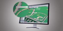
The IMMS graphics update includes the ability to create one or more map views for control purposes. You can see where all of your irrigated locations are, and click any for a more detailed view or control purposes.
Ideal for orienting new employees, IMMS Graphics also simplifies life for busy irrigators with large numbers of assets to control. Use any background image to show the system, site, or controller area, and create control zones and station symbols that link to their command functions. You supply the pictures, and IMMS includes all the tools you need to create an interactive map-based system. IMMS can also import CAD linework for truly intelligent custom maps.